

New Jersey on Thursday will see a smaller piece of the massive severe weather outbreak hitting the center of the country early this week.
First off, it’s good to be back in the weather saddle at The Press of Atlantic City. It looked like Bayfest had decent weather and we had a few tastes of summer, too.
Looking to the future, the Storm Prediction Center, a government agency based in Norman, Oklahoma, on Monday placed South Jersey in a risk for severe weather Thursday. Likely, this will be Thursday afternoon and evening.

The main threat will be damaging winds. Small hail will be possible, too. To a lesser extent will be tornadoes and large hail. So we could have it all.
The best course of action for now is to cut down or prepare to take in anything that can be blown around by strong winds. The tornado threat is a low one, but review where you’d go if caught in a tornado warning. Basements, low levels of a building away from windows or a storm shelter are best. Outdoor plans during the p.m. should be moved if you want to play it safe, though I’ll have more details on timing in the days to come.
People are also reading…
This severe weather potential comes as a low-pressure system is ejected eastward, our way, bringing showers and storms. Flooding rain is unlikely, as the ground can handle a lot of rainwater right now.
Before we get to that, we have Tuesday and Wednesday. They’re fairly similar. Both will have some rain, though it’ll be mostly dry. In the case of Tuesday, expect showers through 11 a.m., mainly south of the Atlantic City Expressway.
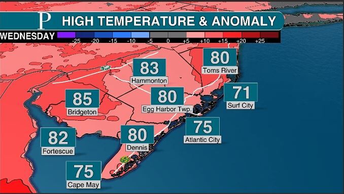
On Wednesday, a round of showers will limp through from 3 to 10 a.m. A number of you will be completely dry during this time.
They’ll both be warm, with summertime humidity around. Highs Tuesday will be in the 70s inland, with 60s at the shore. Wednesday will feel like the summer to come. Expect temperatures in the 80s inland, with a decent beach day as the shore tops out between 70 and 75 degrees.


Both days also will have coastal flooding. Tuesday night from 7 p.m. to 1 a.m. and then Wednesday night from 8 p.m. to 2 a.m. will be the main times for this. On the Atlantic Ocean side, and the back bays, this will be minor flood stage. It’ll be a little tough to drive around the bayside towns but not impossible. We see this a few dozen times a year.
As the weather warms and days get longer, boats fill up Sen. Frank S. Farley State Marina in Atlantic City. Here's a drone tour of the region during the spring. It is a public marina, managed by the Golden Nugget
The Delaware Bayshore in Cumberland and Salem counties has the bigger issue. The Wednesday night high tide should be in moderate flood stage. Driving around will be impossible in places. Up to a foot of salt water will be standing in spots.


Looking all the way down the road, Mother’s Day weekend will be pretty cloudy and cool, but mostly dry. The only shot of rain likely will be late Sunday.
Start thinking about celebrating Mothers' Day inside on Sunday. Meteorologist Joe Martucci, Certified Digital Meteorologist, says a weak coastal storm will be possible for the holiday. Tune in to see what to expect.
Finally, as someone who recently got off a plane, weather usually takes center stage during a flight. Most of us fly commercial, not private (though we can dream). So we get a behind-the-scenes look at Southwest Airlines’ massive weather operation on the latest Across the Sky podcast. We speak to David Dillahunt, chief meteorologist for the airline. Listen at PressofAC.com or wherever you get your podcasts.


Welcome to the discussion.
Keep it Clean. Please avoid obscene, vulgar, lewd, racist or sexually-oriented language.
PLEASE TURN OFF YOUR CAPS LOCK.
Don't Threaten. Threats of harming another person will not be tolerated.
Be Truthful. Don't knowingly lie about anyone or anything.
Be Nice. No racism, sexism or any sort of -ism that is degrading to another person.
Be Proactive. Use the 'Report' link on each comment to let us know of abusive posts.
Share with Us. We'd love to hear eyewitness accounts, the history behind an article.