
A weak coastal storm will develop Thursday off the Jersey Shore, bringing a heavy mist and showers for some. Friday will then be mostly dry. A few showers look likely Saturday.
We should wind up with a large shore vs. inland difference in our weather Thursday, and not just because of the temperatures.
Along and east of the Garden State Parkway, especially in Atlantic County on north, there will be drizzle, mist and low clouds pretty much all day long. Couple that with a breezy wind out of the northeast, and it’ll be a raw day from Atlantic City to Long Beach Island and points north. You’ll need to move your outdoor plans there.
Elsewhere, there will be some drizzle and mist. However, it’ll be less and less frequent as you move west from the ocean. In fact, places like Bridgeton will have sun at times.
The difference in weather will lead to a difference in temperatures. Morning lows will be around 50 degrees everywhere. However, high temperatures will range from the lower 50s in coastal Ocean County to the upper 50s in Cape May to the 60s west of the parkway.
People are also reading…
This is all thanks to a back door cold front. Really, it’s a cold front that moves from northeast to southwest instead of the usual west to east. This ushers in moist, northeast winds that bring these type of dreary days.
Low-level moisture will lessen into the night. So once the sun sets, the drizzle will decrease. Temperatures will fall into the 40s.
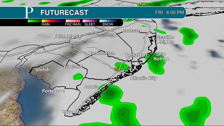
By Friday, the cold front will be far enough south to allow a sliver of high pressure to snake in from Nova Scotia, Canada. Winds will be out of the east again, but given the high pressure, it’ll be a dry feed of air. That is, until the cold front moves in from the west. A few spots of coastal flooding will be around from 4 to 9 a.m., with most flood free.
So most of the day will be rain free. You’ll have a mix of sun and clouds with afternoon highs in the mid- to upper 50s.
That should be between 5 and 10 p.m. An hour or two of rain will be possible. I bet a number of you will be completely dry. If you have outdoor evening plans, keep them, but have an indoor plan B available.

The cold front will then slow down and linger off the shore Saturday. Add in the strong April sun beating down on the ground, and you have yourself isolated Saturday afternoon showers.
Similar to Friday evening, many of you will be rain free. About an hour’s worth of rain will fall, at most.
High temperatures will climb back to more seasonable levels. It’ll be in the upper 60s inland to the low 60 at the beaches.
I feel good saying Sunday will be dry now. That storm system should stay so far south that we’ll be rain free. Onshore winds will make temperatures cooler than Saturday, with low 60s inland and upper 50s at the shore.

Finally, a programming note. I’ll be off the next couple of days. I’ll see you online with a fresh weather video at 5:30 a.m. Monday. You’ll see a column from me Tuesday.


Welcome to the discussion.
Keep it Clean. Please avoid obscene, vulgar, lewd, racist or sexually-oriented language.
PLEASE TURN OFF YOUR CAPS LOCK.
Don't Threaten. Threats of harming another person will not be tolerated.
Be Truthful. Don't knowingly lie about anyone or anything.
Be Nice. No racism, sexism or any sort of -ism that is degrading to another person.
Be Proactive. Use the 'Report' link on each comment to let us know of abusive posts.
Share with Us. We'd love to hear eyewitness accounts, the history behind an article.