

For the first time in a while, we can say two things. First is that you can begin planting in most of South Jersey this week. The second is the upcoming stretch is pretty darn dry.
The old adage goes that you should wait until Mothers' Day to begin planting in NJ. Meteorologist Joe Martucci says for some parts of the state, you can begin planting now or at least very soon. The final frosts and freezes of the year are likely on the way.
Monday was likely our last widespread frost of the season. Places like Woodbine in Cape May County got down to 32 degrees. Most of the Pine Barrens was below freezing.
Tuesday, Thursday, Friday and Saturday will have frosts and freezes, but I don’t expect them to be as widespread. This should mainly be confined to the Pine Barrens in Burlington, Ocean, Atlantic and Cumberland counties.
Cape May County could be frost or freeze free for the rest of the season. The National Weather Service left the county out of the frost advisory for Tuesday morning.
What we’re going through is pretty typical for this time of year. If you’re at the immediate shore, your growing season already began. The last widespread freeze was March 20. The last day with frost possible, say a temperature at or below 36 degrees, was March 30. Lows will be at least a few degrees above freezing each morning.
People are also reading…
For the non-Pine Barrens inland areas, you’re likely OK to start planting. A frost or freeze will be possible Tuesday or Thursday through Saturday mornings, but it will be brief. Figure it lasts for an hour or two. Most plants can handle that. Lows will be between 30 and 36 degrees.


April in the Pine Barrens is a tough month to put sensitive crops or plants out. The average last freeze in Indian Mills, Burlington County, is May 1, so you’ll need to hold off this week. Lows will regularly be below 32 degrees, with 20s likely somewhere each morning.

The good news for growing is that this looks to be the last longer stretch of cool weather until the fall. Once we turn the page to next week, the Climate Prediction Center says temperatures will be “likely above” average. Think more highs in the 70s (inland) and 60s (shore), with lows in the 50s.
Tuesday will have that same brilliant sunshine as Monday, just with warmer temperatures. Highs will be in the mid- to upper 60s inland, falling to the upper 50s at the immediate shore, as a sea breeze front moves in.
Tuesday night will be the mildest one of the week. The sky will cloud up, and winds will be out of the south. Lows will be in the 45- to 50-degree range. Coastal flooding will be around in the Barnegat and Delaware bays from 9 p.m. to 2 a.m. This will be minor flood stage, with just a few inches of salt water.
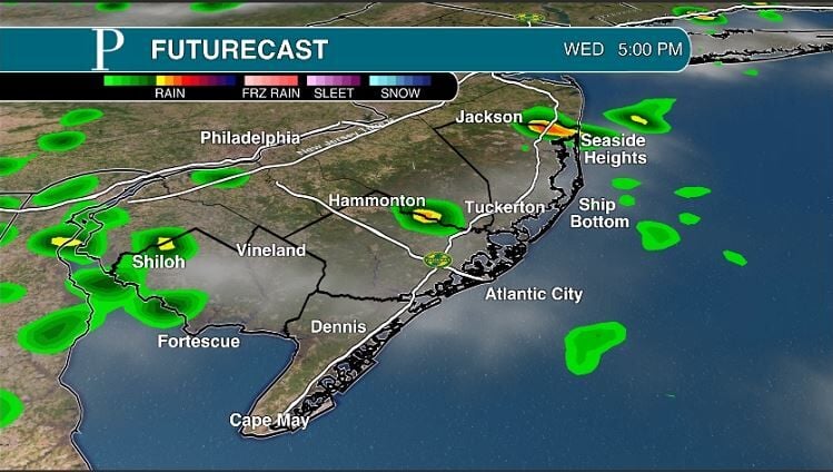
That will set up our only day of rain this week, Wednesday. Rain will be possible at any point in the day as a cold front slowly slides through the area. More than likely, you’ll see this occur during two distinct time frames.
The first will be 4 to 9 a.m. That’ll be with the cold frontal passage. Up to two hours of rain will be likely.

The second will be from 2 to 9 p.m. This will be hit-or-miss showers that come through as unstable air moves in behind the cold front. Another hour or two of rain will be likely. Don’t be surprised to see small hail, too.

Wednesday also will be the warmest day of the week. Highs will be in the mid- to upper 60s.
A new Canadian high-pressure system will settle in for the rest of the week. This will bring dry but cool weather, chilly enough for those morning frosts or freezes.
Highs will be in the 50s both days. The shore will barely crack 55 degrees Thursday. Bundle up.

An early look to Bayfest Saturday in Somers Point shows a dry day. However, it’ll be close. Rain should fall during the evening or night as a cold front passes. Monitor the forecast to see if there are earlier changes.
Finally, negative stories about climate change come at us every day, but there are positive stories that illustrate the innovations being made to slow the pace of the warming climate and conserve the environment. In honor of Earth Day, CNN’s chief climate correspondent Bill Weir joins our Across the Sky podcast to share some of those stories from his world travels. Find it at PressofAC.com or wherever you get your podcasts.


Welcome to the discussion.
Keep it Clean. Please avoid obscene, vulgar, lewd, racist or sexually-oriented language.
PLEASE TURN OFF YOUR CAPS LOCK.
Don't Threaten. Threats of harming another person will not be tolerated.
Be Truthful. Don't knowingly lie about anyone or anything.
Be Nice. No racism, sexism or any sort of -ism that is degrading to another person.
Be Proactive. Use the 'Report' link on each comment to let us know of abusive posts.
Share with Us. We'd love to hear eyewitness accounts, the history behind an article.