

Three rounds of rain will pass through the region between now and Friday. While rain is the last thing we need after this record wet start to 2024, at least there will be dry time.

The sea breeze front can either bring pleasant relief to the summer heat near the shore. Or, it can put you in jackets while those inland stay in shorts.
This all stems from a large upper-level low-pressure system that will move from the Great Lakes north to Ontario the next couple of days. It’s the same system that brought severe weather to the central United States earlier this week.
I believe you can still break the rain down into three parts.
New Jersey is at an above average risk for a tropical storm or hurricane to hit or be within 50 miles of the coast this year, according to Colorado State University's April forecast. Meteorologist Joe Martucci shares the county-by-county breakdown for 2024's risk. CSU put out their most active forecast since beginning to forecast upcoming seasons in 1984. The expect very active hurricane season is due to two factors. La Nina is expected to replace El Nino this hurricane season. The cooling of the waters along the equatorial Pacific Ocean plays a role. In additional, ocean water temperatures in the tropical Atlantic Ocean remain well above average. Joe details both.
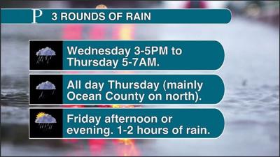
Part 1: Wednesday between 3 and 5 p.m. to Thursday between 5 and 7 a.m. This will be the wettest period. Expect rounds of rain and even thunderstorms. Any thunderstorms could bring a gusty wind and small hail.
Part 2: All day Thursday. A front will be stationary over our area. The latest forecast computer models are painting a tale of two South Jerseys. If you live in Ocean County, it’s a damp, dreary day with a stiff wind out of the east. Highs will be in the low to mid-50s. Heavy drizzle and rain showers will fall pretty much all day long.
People are also reading…
Meanwhile, Cumberland and Cape May counties will see just spotty drizzle and showers. Most of your day here will be dry, though it’ll be raw with an onshore breeze. Highs will be between 60 and 65 degrees. Atlantic County will be somewhere in between. Cancel your outdoor plans just to be safe.
Part 3: Friday p.m. A cold front will pass through, signaling the end of the low pressure’s wet influence. There will just be an hour or two of rain between 4 and 10 p.m. Think of it as a good warmup for the pop-up summertime showers and thunderstorms that will come later. Most of your day will be dry and less breezy. The morning will start out in the mid-40s. The afternoon highs will be in the mid- to upper 50s.

I am keeping an eye out for coastal flooding Friday morning. The strong onshore winds Thursday will definitely lift tide levels. At the same time, we’re in a quarter moon, where tides are naturally lower.

Below are Jersey Shore locations with previous and forecast tide data. The forecasts show wh…
I tend to think the winds will win this battle and we get into minor stage coastal flooding. This would be for an hour or two between 4 and 9 a.m. Friday.
Then, we get to the weekend. Saturday looks fantastic. Expect dry and seasonable conditions, with highs in the 60s. There still looks to be a storm to our south Sunday that may bring rain. If you have weekend outdoor plans, move them to Saturday, or hang on another day as I tighten up this forecast.
Finally, this didn’t make it at the time of writing, but Atlantic City International Airport wound up reaching 86 degrees Monday. That didn’t break the daily record, but it was three weeks ahead of schedule, according to the National Oceanic and Atmospheric Administration. It was our warmest day since Sept. 12, 2023.


Welcome to the discussion.
Keep it Clean. Please avoid obscene, vulgar, lewd, racist or sexually-oriented language.
PLEASE TURN OFF YOUR CAPS LOCK.
Don't Threaten. Threats of harming another person will not be tolerated.
Be Truthful. Don't knowingly lie about anyone or anything.
Be Nice. No racism, sexism or any sort of -ism that is degrading to another person.
Be Proactive. Use the 'Report' link on each comment to let us know of abusive posts.
Share with Us. We'd love to hear eyewitness accounts, the history behind an article.