

Protect your belongings against strong winds late Thursday into Friday morning. If you have a generator, keep the fuel handy. If you have moved your car due to the coastal flooding lately, do that again, too.
A strong low-pressure system, the same one that brought severe weather to the Deep South on Wednesday, will move through the Great Lakes states into eastern Canada on Thursday.
New Jersey will be on the eastern side of that storm. With a strong cold front approaching, too, we’ll be hit with strong winds, a few hours of heavy rain and coastal flooding due to continued onshore winds.
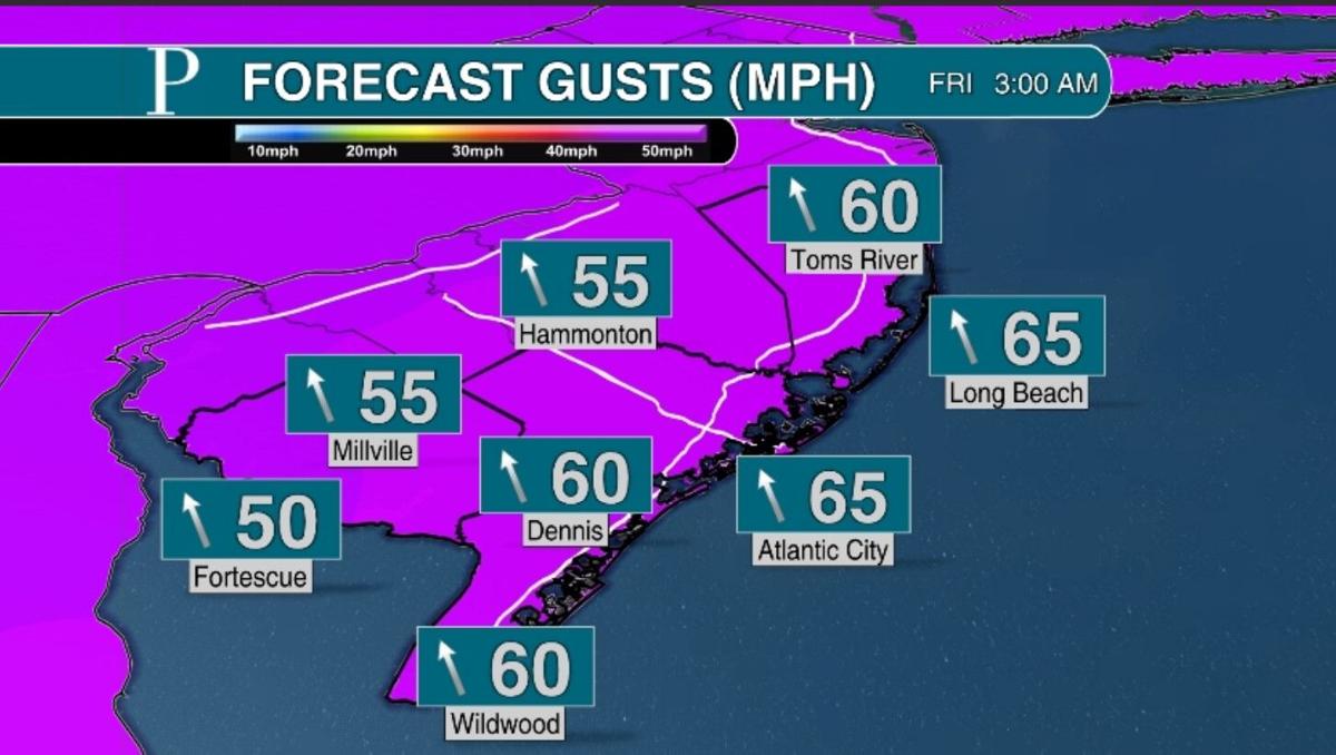
From Thursday evening to Friday morning, wind gusts will be over 40 mph inland. Along and east of the Garden State Parkway, they’ll be above 50 mph. This doesn’t include any severe gusts that occur if a thunderstorm rolls through. Winds will be from the southeast Thursday, flipping to the west Friday.
People are also reading…

When the winds are strongest, the rain will be heaviest, too. Rain will begin between 5 and 7 p.m. Thursday. Rounds of heavy rain will be around until between 3 and 5 a.m. Friday. If you see a thunderstorm, it’ll likely be after midnight.

There is a near record amount of moisture in the atmosphere for mid-April, according to the National Weather Service in Mount Holly, so rain will be heavy enough to lower visibility and impact driving. Rainfall totals will be 0.6 to 1.2 inches. That’s usually enough to cause low-end road and property flooding issues. However, given how wet we’ve been this year, expect a higher risk of flooding than if this rain fell during a dry spell.
Coastal flooding will continue as well. Between 10 p.m. and 4 a.m. Thursday, you can expect a few hours of flooding near the bays. The good news is this will largely be minor flood stage, like we’ve seen over the past week, so it’s the nuisance kind that will bring a few inches of salt water to low-lying roads. Surge will be about a foot.

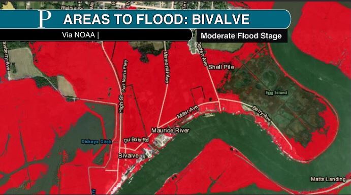
However, the south-facing shores of the Delaware Bay, and the tidal rivers, will likely be in moderate flood stage. It’ll be tough to drive around Fortescue, Bivalve and the like down by the bay. That’s because winds out of the south will push water right up into the bays.


So, to recap, strong winds, heavy rain and coastal flooding will all be concerns late Thursday into Friday morning. This will leave most of your Thursday dry. As long as you can handle a breezy day, your outdoor plans will be fine until about 5 p.m.

Morning temperatures will be 45 to 50 degrees. Afternoon highs will have a big range again. Ocean County and most of the shore will be in the 50s. Atlantic and inland Cape May counties will be in the 60s. Head west of there, and the rest of South Jersey will be in the 70s.
Friday during the day will be windy and wet at times. Wind damage and power outages will be possible as winds stay strong out of the west.
In terms of rain, about an hour’s worth will fall from 7 to 11 a.m. Friday. Then, up to another 60 minutes of rain will be around during the afternoon. This can be heavy, and don’t be surprised if small hail falls with it.

So, between the wind and showers, Friday’s weather may end up canceling your outdoor plans. High temperatures Friday will be in the low to mid-60s.

I still like the idea of a dry and mild weekend. Winds will be breezy from the west Saturday, but it won’t be as strong as Thursday or Friday (sustained winds 15 to 25 mph). Highs will be in the low to mid-60s.
The wind will finally diminish Sunday. That’ll allow the sun to heat up the ground, making it even warmer. Inland spots should touch 70 degrees, a few degrees cooler at the shore.


Welcome to the discussion.
Keep it Clean. Please avoid obscene, vulgar, lewd, racist or sexually-oriented language.
PLEASE TURN OFF YOUR CAPS LOCK.
Don't Threaten. Threats of harming another person will not be tolerated.
Be Truthful. Don't knowingly lie about anyone or anything.
Be Nice. No racism, sexism or any sort of -ism that is degrading to another person.
Be Proactive. Use the 'Report' link on each comment to let us know of abusive posts.
Share with Us. We'd love to hear eyewitness accounts, the history behind an article.